Hydraulic Design
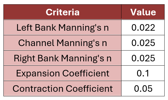
The roadside ditches utilized were designed in accordance with the CCEDCM and the CCDDCM. The ditch was modeled using HEC-RAS pursuant to CCDDCM 4.2. Flow was analyzed in 50’ cross sections along the proposed road alignment. A summary of Manning’s n values and contraction and expansion coefficients for the proposed channel is shown below in the table below.
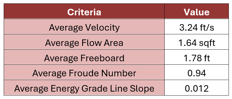
The left and right reach lengths were determined by measuring the relative overbank distances between cross sections. Only the west channel was modeled, as the east channel is simply a mirror of the west channel. All design storm and flow characteristics were determined from the previous hydrologic analysis. A summary of the results from the HEC-RAS analysis is shown below in the table below.
Roadway Design
Design Vehicle
The design vehicle is based on the largest truck the High-Country Fire Rescue department uses. This department is a half mile away from the site and would be the quickest responder in the case of an emergency. The largest vehicle they would utilize is the 2001 KME International 4x4 Commercial Type 3 Quick Attack. It has a width and height of 10ft and a length of 30ft. It has a max weight rated at 35,000 lbs. Most other fire trucks fit within these specifications. This vehicle corresponds to AASHTO design vehicle WB-62.
Cross-Section Design
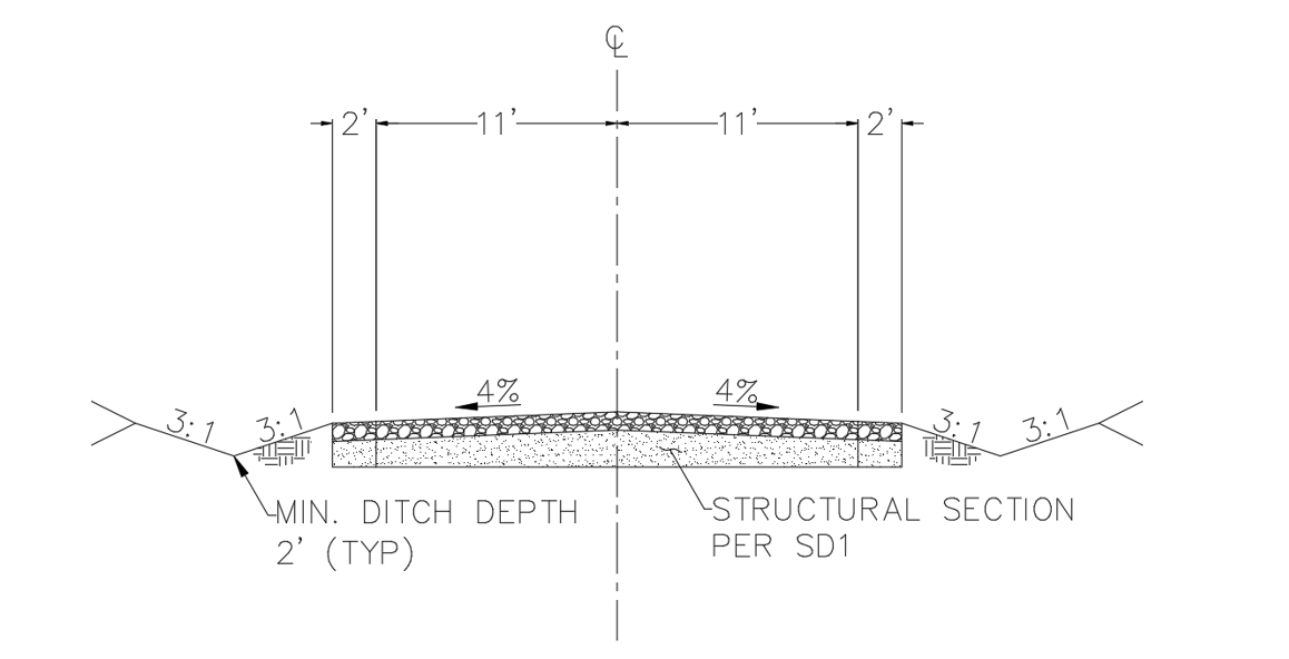
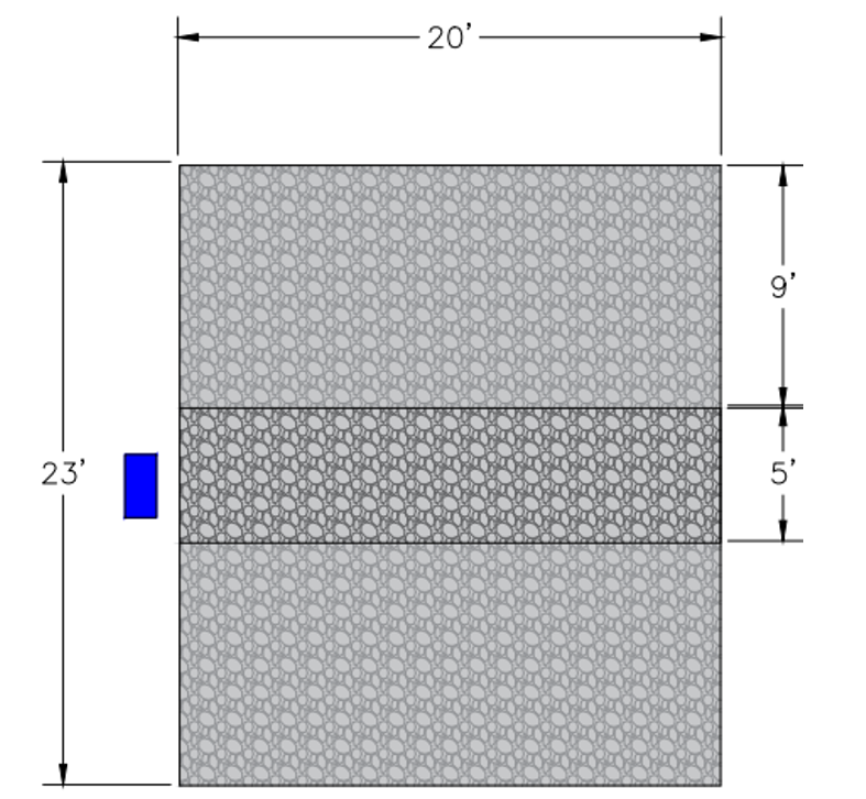
The AASHTO Green Book recommends low volume rural roads be 18’ wide, however a width of 26’ was selected to better accommodate the design vehicle through large turns. The sides of the road will either be paved to grade or a ditch dug out based upon drainage information to be determined later on. It will have a crown of 4% which is the average for roads such as the one being designed. The image of the cross-section is shown below.
Design Speed
The design speed will be 10 mph. This was determined based on the relatively short length of the roadway, curved alignment, and loose surface materials in accordance with the AASHTO Guidelines for Geometric Design of Low-Volume Roads.
Pavement Design
Alternative Selection
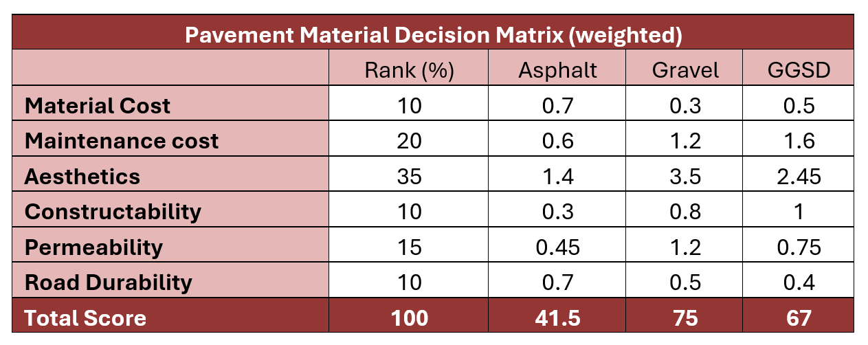
The pavement material was selected based on the following criteria: material cost, maintenance cost, aesthetics, constructability, permeability, and durability. The desired pavement surface was a flexible pavement of which the following alternatives were considered: asphalt, gravel, and geogrid stabilized earth road surface (GGSD). The decision matrix below shows the weights of each criterion, and the weighted scores assigned to each alternative. The selected alternative was gravel.
Final Pavement Structure Design
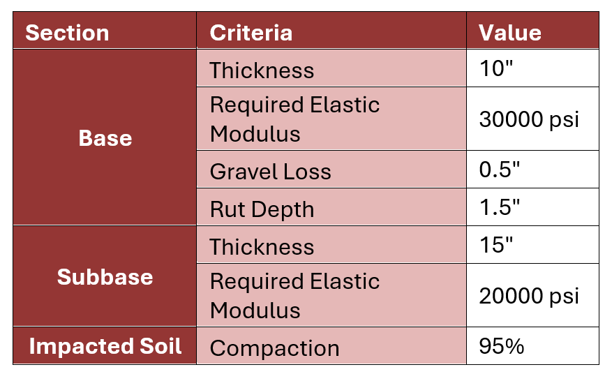
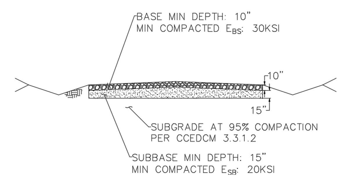
The final structural section of the pavement was designed in accordance with the CC Engineering Design and Construction Manual, the ADOT Pavement Design Manual, the AASHTO Guide for Design of Pavement Structures, and the Forest Service Road Preconstruction Handbook as required. The table below shows a summary of the structural section design. The image below shows the pavement structure detail.
Road Alignment Design
Horizontal Alignment
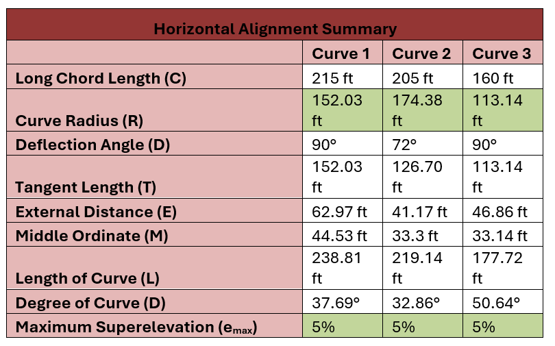
The table below is a summary of the horizontal alignment values verified using Excel. The highlighted values show the values that are checked against the AASHTO curve requirements from the table above. All three curves meet the requirements.
Vertical Alignment
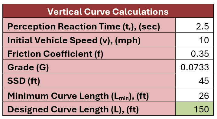
The length of the designed vertical curve was checked using Excel. The table below shows the values used to determine the stopping sight distance (SSD), which was then used to determine the minimum vertical curve length. The perception time and friction coefficient are both given values from AASHTO for rural roads.
Ingress and Egress Treatment
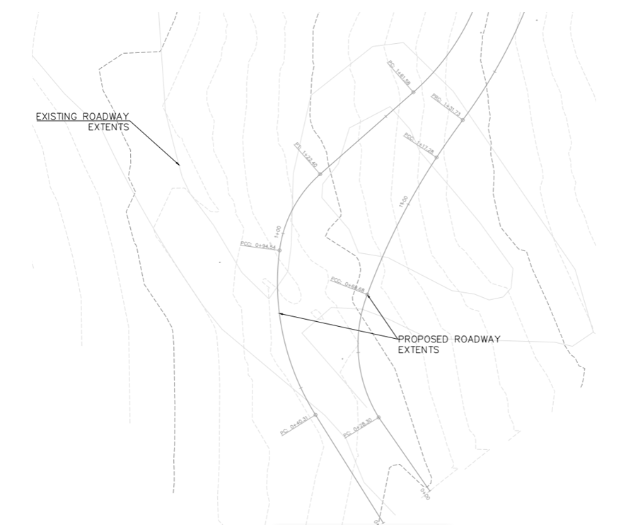
N Joshua Tree Road will be connected the MWC road with a paved turn. It will be able to accommodate the design vehicle as it turns into site and exits site as shown below. The image below shows the ingress and egress access points for the proposed road.
Site Design
Parking Space Design
The approximate size of a large single-unit truck (i.e., F150) is about 8’x20’. In order to accommodate large single-unit trucks, be ADA compliant, and comply with Ordinances, the maintenance shed parking space will be 23 ’ x 20’. This gives space for two large trucks to park side by side with a 5’ isle, while complying with all three constraints. The two single parking spaces will be 14 ’ x 20’ to accommodate one single-unit truck and be in ADA compliance. Both types of parking spaces will be paved with gravel. The larger parking space design, as created in Civil 3D, is shown below.
Site Grading
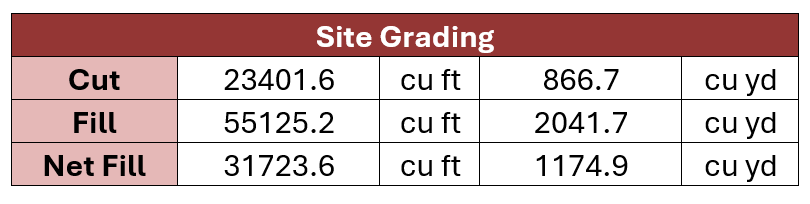
The site grading was completed using the grading optimization tool in Civil 3D, in order to determine the amount of cut and fill that will be required. The drip line of the remaining mature trees is excluded from the site grading, in order to prevent causing harm to the root systems of the trees. The table below shows the amount of cut and fill as determined by the grading optimization tool.
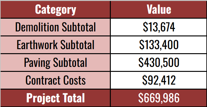
Construction Costs